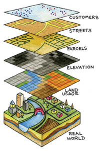
 The NYS GIS Association was awarded a $10,000 grant by The Fund for The City of New York to assess the GIS needs and resources for municipalities throughout NYS and identify potential strategies and solutions for the increased use of GIS. Although GIS is used extensively in many areas, there are still places in New York that do not use GIS or could use it more effectively. GIS is a technology through which communities can use computerized maps to analyze and improve a municipality’s planning, asset management, emergency response, disaster services, humanitarian aid, and other vital public functions.
The “Emerging GIS Series: Emergency Response” video shows real-life examples on how important GIS is to local governments and fire departments for emergency response. The video can be viewed on the NYS GIS Association’s YouTube channel at https://youtu.be/VSCT6sGUROA or on the NYS GIS Association’s Emerging GIS webpage at http://www.nysgis.net/emerging-gis-resources/ .

