PRESIDENT
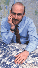
Alan Leidner

Dear GISMO members,
I am running for another two year term as GISMO President. If elected I do not plan to run again in 2022. I use will another term in office to help prepare new GISMO leadership, while continuing to build GISMO’s membership, activities and influence.
As current President and in collaboration with the GISMO Board and with activist members, we have achieved much over the past years. GISMO membership now tops 400. We have vastly increased student membership by eliminating dues and paying for student membership in the NYS GIS Association (NYSGISA). We have organized Job Fairs (Amy Jeu), lectures and presentations by City GIS practitioners and industry leaders. We developed a Principles and Practices platform and held a well-attended Forum to discuss and debate the various platform proposals. We have aggressively pursued alliances with other organizations including the NYSGISA, the Open Geospatial Consortium (OGC) and the American Geographical Society (AGS). We have also created a large network of GIS related groups called COGITO (Noreen Whysel): the Coalition of Geospatial Information Technology Organizations. COGITO contacts include representatives of all colleges and universities that teach GIS, including Lehman, Hunter, NYU, Columbia, and Pratt. We will also build on our commitment to public data, working to guarantee that the City’s open data sets are fully geo-enabled, user friendly and capable of easy interoperability and analysis. Most recently we have worked on developing GIS legislation for consideration by the NYC Council that would mandate the appointment of a City GIO, a GIS Strategic Plan and a GIS Steering Committee (Wendy Dorf, Jack Eichenbaum).
Over the next two years we will continue to hold informative events that will bring our GIS community together and foster collaboration and friendships. An Applications Fair to showcase City agency GIS progress is scheduled for November 20th. We will focus on making NYC “smarter”, finding ways for GIS to be integrated into evolving technologies such as sensors, artificial intelligence and big spatial data analytics. Our mission, as always, is to help make NYC a safer and more prosperous City through the innovative use of spatial data and technologies.
BOARD OF DIRECTORS
Wendy Dorf

I was employed in City government for thirty-five years, and for twenty of those years I managed mapping projects at the Department of Environmental Protection. The first project I managed was the mapping of the Citywide Water Main System, one of the earliest digital maps of this magnitude. The success of this project paved the way for digitizing the sewer system and finally for the development and implementation of the New York City basemap, along with my colleague Alan Leidner and others. I became DEP GIS Director shortly before 9/11 at which time I was directed to manage a team of engineers and GIS experts to map the infrastructure beneath the remains of the World Trade Center to enable first responders to navigate the site safely. The team was known as the Deep Infrastructure Group (DIG).
Since retiring from government, I have consulted on numerous infrastructure digital mapping projects. I am a founding member of the New York Geospatial Catalysts (NY GeoCATS), whose mission is to jump start geospatial projects for the benefit of the citizens of our city. A prime initiative of NY GeoCATS is the development of the infrastructure integration project. The Fund of the City of New York kick-started this mission by generously providing funds to the Open Geospatial Consortium, (OGC), for development of a standardized data model to enable data integration and sharing. This initiative was embraced and directed by the Mayor’s Office. Currently the Department of Design and Construction, (DDC), is scheduling meetings to discuss construction and other agency needs that may benefit from data integration and sharing.
I recently testified before the City Charter Commission in support of GIS amendments to City Charter-DOITT (Chapter 48), mandating leadership, planning, collaboration and creation of standardized data and formation of a utility data steering committee. I have been working with legislators who are drafting legislation to accommodate these amendments.
I have served on the GISMO Board of Directors for three terms and have been a member of GISMO since the 1990’s. I have been dedicated to advancing geospatial technologies and projects for most of my career and over the years have become a steadfast advocate of the benefits derived from using GIS to improve efficiencies and the quality of life everywhere. I wish to serve on the Board of GISMO for another term as GISMO is the premier organization that supports and informs the community about everything GIS.
Jack Eichenbaum

I hold a Ph.D in geography from the University of Michigan (1972.) My dissertation research employed “computerized cartography,“ a primitive form of GIS. I continued academically as an assistant professor at the University of Washington but fell off the tenure track in 1975. I returned to my native NYC where in 1982 I became employed by the NYC Dept. of Finance as it began the computerization of its property tax valuation system.
Founding GISMO in 1990 was the best thing I did in 23 years of working in NYC civil service. Large local governments, like modern corporations and universities, are organized hierarchically so that information does not flow easily across agencies. Yet the problems we face clearly overlap agencies.
In 1990 I was using GIS to generate computerized property valuation for property taxing purposes in the NYC Department of Finance. I needed information about crime, school quality, demography and other data to help explain the variation of property value based only on physical characteristics. I also needed to learn more about GIS technology. With the blessings of my supervisors, I was able to devote time to organizing.
Some of my initial concerns have been addressed. There is a GISMO based GIS camaraderie in NYC which extends to the non-profit and private sector as well as different levels of government. At the Department of Information Technology and Telecommunications, data have been aligned to a common base map. And data now flows freely! We have a NYS-wide organization to bring us together on that level. (I participated in the early organizing efforts of that!)
Yet there are still some concerns that have not been well addressed. In general, data quality is not being maintained. As more expenditures have been directed toward computers and software, funds and priorities have shifted away from basic data collection and accuracy. Furthermore, NYC is located at the core of a tristate multi-county metropolitan area. For investigating transportation, ecological and and economic development issues, data needs to be able to cross political boundaries. At this time, metadata and data quality standards differ sharply among the municipalities, counties and states in Greater NYC. While GISMO has always welcomed participation from our neighbors, this has not resulted in much formal progress in solving data migration issues.
I retired from the NYC Department of Finance in 2005. When I did, my access to familiar GIS software and the rich property data base retired with me. My activity shifted more to fundamental exploration of NYC. (Exploration is the laboratory for the science of Geography.) I now teach Geography of NYC and also lead about 30 walking tours a year in different parts of NYC for a variety of groups. I am active in community affairs, particularly where expertise in history and geography is called for. (Since 2010, I have served as the official Queens Borough Historian.)
I felt such joy at GISMO’s 25th anniversary celebration in 2015 and look forward to celebrating GISMO’s 30th anniversary in 2020.
Amy Jeu

I hold a Master of Geographic Information Science (MGIS) Degree from the University of Minnesota and a Bachelors of Arts degree in Geography from Hunter College, CUNY. I currently work for the Department of Geography and Environmental Science at Hunter College as a Geoscience College Laboratory Technician (CLT) and have taught GIS courses at Hunter.
Karen Rutberg, former CARSI employee, introduced me to the GISMO family in 2005 and I’ve been a member ever since. I started out attending meetings and updating the GISMO website, and over time became a more committed member. I have served three terms on the GISMO Board of Directors and would like to continue serving as a Board Member for another term.
As a Board Member, I serve as the Membership Secretary and Director of Communications, working in close collaboration with the NYS GIS Association maintaining the membership database, sending notices and announcements to all members, and creating digital and printed media. The President of GISMO and I work in tandem ensuring our official means of communication with members and the public are current and up to date. As an integral member of the GISMO Bylaws, Nominations and Elections Committee, we develop procedures to ensure the vitality and longevity of GISMO; ensure that elections are conducted properly and fairly; and seek nominations for Board positions.
For the past two years, I successfully lead GISMO’s GIS Job & Career Fair at Hunter College. My desire is to grow and expand this event annually.
NYC’s Geospatial Architecture remains a top priority. Earlier this year, joined by fellow GISMO members, I testified at the New York City Charter Revision Commission 2019 Borough Hearings advocating for a City Geospatial Information Officer (GIO), a GIS strategic plan, a GIS steering committee, spatial data standards, and an underground infrastructure data committee. This resulted in work with the NYC Council for GIS legislation, currently led by Alan Leidner, Wendy Dorf and Jack Eichenbaum.
GISMO’s contributions are recognized nationally and internationally. I was a 2018 recipient of the NYS GIS Association Individual Contributions to the Profession award. In 2019, I had the privilege to be interviewed by the Korean Broadcasting System (KBS) for a Special Documentary on Smart Cities.
My goals for another term in office are membership outreach; creating more opportunities to socialize and network with each other; and enhancing the GISMO website. I look forward to GISMO’s 30th anniversary celebration in May 2020.
Juliana Maantay

I have been a “GIS-er” since the early 1990’s, but an “unofficial” geographer all my life. As a native New Yorker, I’ve had a life-long interest in the urban environment, especially that of my home-town. I consider myself fortunate to have a job allowing me to combine this fascination with urban culture, history, and the built environment with my passion for social justice.
I founded and direct the GISc Program and the Urban GISc Lab at Lehman College, City University of New York. As a professor in the Earth, Environmental, and Geospatial Sciences Department, I’ve designed and taught over a dozen different introductory and advanced GISc courses since 1998, and developed a GISc Certificate, a Master’s of Science in GISc, an Accelerated Bachelor’s to Master’s program in GISc, a robust GISc Internship Program, and a Summer GIScience Academy for high school students. My main research foci are environmental justice, health disparities, and exposure/risk assessment, specifically in urban areas, and I am a strong proponent of Public Participatory GISc and using GIS to inform policy- and decision-making in the public arena. For 25 years prior to my academic career, I was an urban planner, environmental analyst, and architect for governmental agencies, non-profit organizations, and environmental and planning firms, served on a number of scientific committees and expert panels for the US EPA, NOAA, and NIH, and conducted pro bono work for community-based groups. I earned a B.Sc. (Environmental Analysis and Design, Cornell University); M.U.P. (New York University); M.A. (Geography/GISc, Hunter College, CUNY); and M.Phil. and Ph.D. (Environmental Geography, Rutgers University).
My objectives in becoming a GISMO board member would be 1.) to help shape policy related to GISc in New York City, and 2.) to encourage more participation of students and young professionals in GISMO, and help create additional opportunities and meaningful experiences for them within the organization and the local environment. The potential contribution of young GIS-ers is oftentimes an overlooked resource – they have a unique future-focused perspective with much to offer the profession, and the profession has much to gain from their active integration into the field. My goal would be to work with the GISMO membership to make this a reality for our next generation of GIS stars and stalwarts.
http://www.lehman.edu/academics/eggs/fac-maantay.php
Dara Mendeloff

It is with great passion and enthusiasm that I submit my application to serve a second term on the GISMO Board of Directors.
In this second term, I would like to lead a GISMO Open Data Initiative that includes a series of events and training surrounding new tools, standards, and uses of open data. Our community needs to improve our dialog and develop a feedback loop on data and data workflows in our city. I hope for these events to culminate with the larger NYC Open Data Week.
For GIS Day this November 13th, I have put together an event to introduce us to applications in Google Earth Engine. These type of events are important for professional development and networking opportunities; I would like to provide the GISMO community with more events like this in the future.
I am a Senior Geographic Information Specialist at the Center for International Earth Science Information Network (CIESIN) at the Earth Institute of Columbia University. My work at CIESIN supports interdisciplinary research projects involving the integration of socioeconomic and environmental data to create data products for the NASA Socioeconomic Data and Application Center (SEDAC) as well as local and regional sustainability related initiatives. Prior to this work, I was a GIS technician/analyst at the New York City Department of City Planning where I was responsible for data creation and management of GIS data sets for representation of NYC’s Zoning Map, Section Map, and City Map features.
I have extensive experience teaching GIS courses as a Lecturer at Columbia University and the New School, as well as mentoring high school students in the Woodland Ecology Research Mentorship (WERM) program at Wave Hill and the Lamont-Doherty Secondary School Field Research Program (SSFRP) at Columbia University.
Most recently I completed a Certificate in conservation & environmental sustainability concentrated in sustainable food systems from Columbia University, I’m a GISP (Certified Geographic Information Systems Professional), I received my MA in geography/GIS from CUNY Hunter College, BS in environmental science and a BA in mathematics/ computer science from SUNY Purchase College.
Jiin Wen

I’ve been part of GISMO for the past twenty years. GISMO welcomed me into the network as a young professional and provided mentorships that shaped my career.
GISMO’s mission is as relevant today as it was in 1990! As a board member, I would like to expand GIS’s relevance on two tracks—its users, bring GIS to high school students. It is a skill set that can get them jobs and open new professional paths they may have not considered before. The technology underpins many technologies and fields we take for granted—like advertising. On that end, it is also important that GISMO engages in the growing sectors, like health care and educational services.
This blueprint is based on my education and work experience; I have been very fortunate that my career path has allowed me to stack architecture, urban planning (3D and spatial data insight) and even a side of multimedia— to produce products/results to support policy and allow ideas and design to take form within a context. My years at the New York City Economic Development Corporation (NYCEDC) gave me access to a wide range of projects, from development projects like Highline to Essex Crossing; business initiatives and programs like Lifesci NYC, FRESH, and RISE: NYC; and Graffiti Free NYC or CleaNYC under service programs. My parents were happy to see I was able to use the degrees I earned: Bachelor of Architecture, Pratt Institute and Master of Urban Planning from Hunter College, CUNY.
A proud and grateful graduate of the NYC public school program, I am a passionate advocate for this institution. I’m on an advisory board for a Career Technical Education (CTE) high school in NYC and was involved in supporting the start of Borough of Manhattan Community College’s (BMCC) GIS program in the Computer Science department. I also served a term as a member of the Community Education Council (CEC) for District 15.
Noreen Whysel

Noreen Whysel has been a member of GISMO since 1990 when she was a real estate analyst at Price Waterhouse. She was an early proponent of developing our online presence through Virtual GISMO and has remained active in planning GISMO activities bridging local and regional GIS practices and educational programs through mentoring, live programming, advocacy, collaboration and social media outreach. This year, Noreen joined a contingent of GISMO members who testified at the NYC Charter hearings on the importance of GIS data and technology oversight and advocating for a GIO Officer for the City if New York. She has led the Coalition of Geospatial Information Technology Organizations to create a link to GIS programs at local universities, meetup groups, data providers, professional societies and public/private partnerships. She represented GISMO at the past two GeoSummits held by the NYS GIS Association and was a 2019 recipient of their Individual Contribution to the Profession award.
Noreen has been a GISMO board member for several years. For the coming year she will continue to build bridges to geospatial practitioners, educators and learners across public, private and nonprofit sectors including entrepreneurial, civic and data science communities. She has had had success connecting GISMO with startup and technology transfer communities. Through these relationships, she will continue to explore opportunities to contribute to the development of a geospatial research hub, one of the core activities of COGITO. Another goal for this thirtieth year of GISMO is to build on the 650 item archive she created with Alan Leidner to document and share the stories of 9/11 emergency mappers in time for the 2021 anniversary. All are welcome to participate.
Douglas Williamson

Doug Williamson is the Director of Operations Research at the New York City Police Department (NYPD). In this capacity he is responsible for the formulation and application of mapping, statistics and other analytic methods to develop and interpret information that assists management with decision making, policy formulation, and other managerial functions.
He has held a number of positions in public sector spanning fields such as technology, housing and law enforcement. Prior to working at the NYPD, Mr. Williamson was the Director of GIS Data Maintenance at the New York City Department of Information Technology and Telecommunications where he worked on a number of public facing mapping applications.
Prior to his career in city government he received his MA and PhD from the City University of New York. During that time he participated in a number of geo-centric research projects centered primarily on crime, public housing and the environment.
In addition to his full-time role at the NYPD, Mr. Williamson is also an adjunct associate professor in the Geography Department of Hunter College where he teaches a variety of classes in GIS, Cartography and Geovisualization and an instructor at Columbia University where he conducts seminars on Data Visualization.
